Springfield, Middletown, Troy to change congressional districts

Ohio Senate Minority Leader Nickie Antonio, D-Lakewood, and Ohio House Minority Leader Dani Isaacsohn, D-Cincinnati, take questions from reporters after the Ohio Redistricting Commission's first meeting on Tuesday, Oct. 21, 2025.

Credit: Avery Kreemer

Credit: Avery Kreemer

Ohio Senate Minority Leader Nickie Antonio, D-Lakewood, and Ohio House Minority Leader Dani Isaacsohn, D-Cincinnati, take questions from reporters after the Ohio Redistricting Commission's first meeting on Tuesday, Oct. 21, 2025.

The Ohio Redistricting Commission agreed today with a bipartisan vote to adopt a new congressional map that would cement Ohio’s congressional districts through 2031.

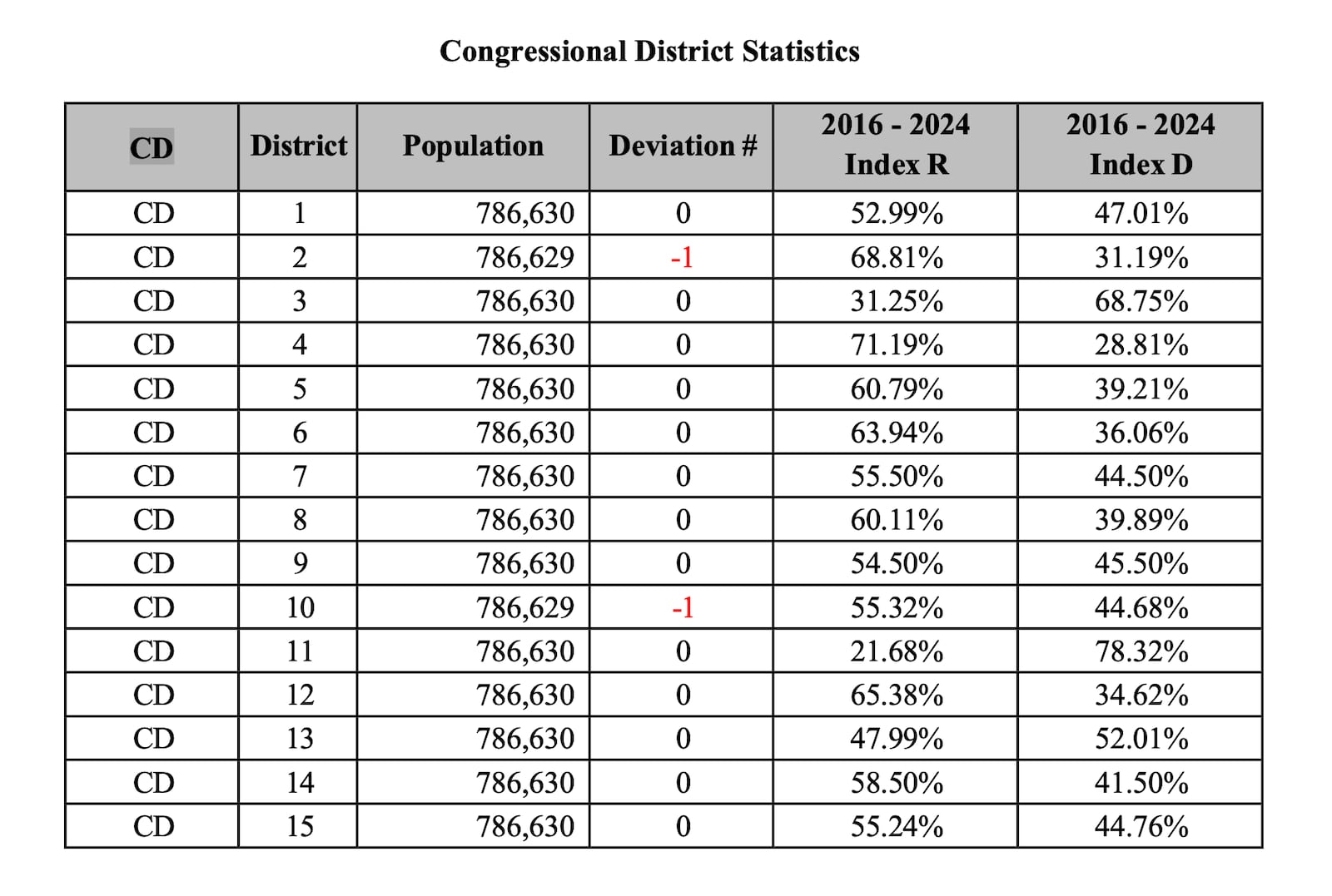
Statewide, the new map gives Republicans an advantage in 12 of Ohio’s 15 congressional districts. Democrats currently hold five seats.

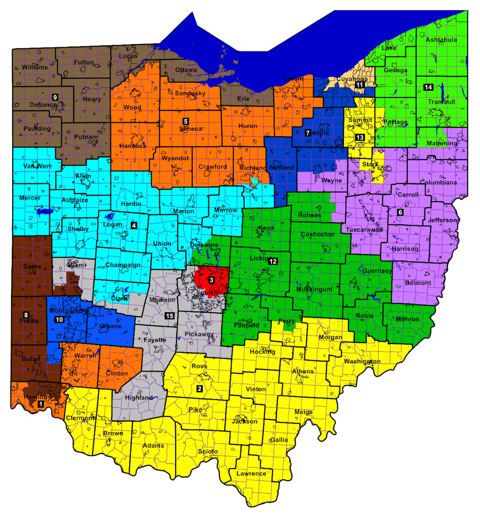
Below is the new map. Here are some key takeaways in the proposal:

Clark County: The last redistricting moved the city of Springfield into the congressional district held by Mike Turner, R-Dayton. The new map moves it again, now to to the district held by Jim Jordan, R-Urbana.

Butler County: All of Butler County is currently represented by Warren Davidson, R-Troy. The new map moves Middletown, as well as Monroe and Trenton, into the district currently held by Turner.

Miami County: Davidson is from Troy but currently only represents a sliver of land south of Troy. The city itself is represented by Mike Carey, a Republican from Columbus. The new map gives Davidson’s district Troy, as well as Tipp City. Carey keeps much of Miami County in a sprawling district that goes through southern Clark County and extends east to Columbus and south to Highland County.

Warren County: Warren County itself stays in the district held by Greg Landsman, D-Cincinnati. But the district picks up all of Clinton County and loses part of Cincinnati, making it more right-leaning. This could put southwest Ohio’s only Democrat in jeopardy.

Here is the new map

Images of the proposed map from the Ohio Redistricting Commission, which was tasked with redrawing the state's 15 congressional maps. The plan creates a 12-to-3 advantage for Republicans, on paper.

Credit: Provided

icon to expand image

Credit: Provided

Here are the current local congressional boundaries updated in 2022

The boundaries of U.S. House Districts 8, 10 and 15 changed this year.

icon to expand image

Here is the new map’s partisan lean

Images of the proposed map from the Ohio Redistricting Commission, which was tasked with redrawing the state's 15 congressional maps. The plan creates a 12-to-3 advantage for Republicans, on paper.

Credit: Provided

icon to expand image

Credit: Provided