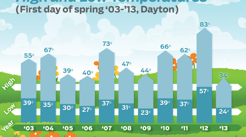
“This time last year we had above-average rainfall, but were in the midst of the amazing stretch of highs in the 70s and 80s that really dried out the ground and started to set the pattern that led to heat and drought all spring and summer,” he said.
Wetter grounds will increase the chances for colder temperatures because spring sunshine will dry the ground.
The chance for cloud development is enhanced, which in turn “limits warming due to less sunshine,” Simpson said.
The overall forecast for March, April and May calls for slightly above-average temperatures, which we should not see until April, he said. But it also calls for above-average precipitation.
“All of this means drought potential is far less than what we were looking at one year ago right now,” Simpson said.
The Old Farmer’s Almanac, a reference book with weather forecasts and planting charts, says April and May will be warmer and rainier than normal.
“Summer will be slightly warmer and rainier than normal” too, the 2013 book says about the Ohio Valley region.
For this week, high temperatures hover in the 20s and 30s.
“A weak disturbance with a reinforcing shot of cold air moves into the area,” Meteorologist Rich Wirdzek said about Wednesday’s weather.
Cold air will linger into Thursday, when temps start in the upper teens.
“The next two days we could see a few stray flurries with the best chance likely coming Thursday morning,” Simpson said.
Friday’s high will be near 40 degrees and Saturday’s in the mid-40s.
“Saturday may be the warmest day of the next week,” Simpson said.
About the Author
