
This week has been designated Severe Weather Awareness Week in Ohio by Gov. John Kasich. It is a good time for all Ohioans to learn what to do to protect themselves from spring and summer weather hazards and home emergencies.
MORE POPULAR STORIES
Wintry mix, accumulating snow expected to cause slick conditions this week
Severe weather awareness: Where to go when there’s trouble
Despite a much more normal winter compared to the last two years, spring severe weather has made an early appearance this year.
The hottest day ever recorded in the month of February occurred on Feb. 20 with much of the state experiencing temperatures well into the 70s. Just five days later, two tornadoes touched down in southwestern Ohio east of Cincinnati. Then, the following day, heavy rains caused a massive rockslide in Lawrence County, closing a major highway for days.
While colder temperatures returned to end the month of February and now with March running well below normal, the latest long-range forecasts show the coming spring will likely bounce back above average for both temperatures and precipitation.
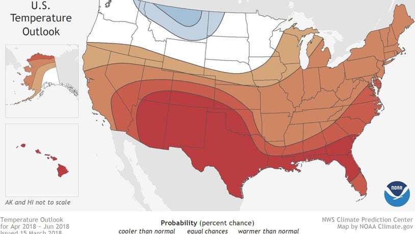
On March 15, the National Oceanic and Atmospheric Administration released its spring outlook for 2018. This 90-day outlook through June is calling for above normal temperatures to encompass much of the United States with the exception of the Northern Plains. The outlook also is calling for above normal precipitation from the Northern Plains into the Great Lakes, Ohio Valley and New England.
While forecasting severe weather weeks in advance is virtually impossible, a warmer than average spring could lead to a more active pattern. This type of pattern has been set up across the southern United States over the last few weeks.
The warmer, more humid air has combined with an active jet-stream (rivers of intense winds high up in the atmosphere), resulting in numerous severe storms. After going a record 283 days without a tornado-related fatality,two people died in tornadoes in Arkansas and Kentucky on Feb. 24.
Over the next few weeks, temperatures will be on the rise and severe weather season will get into full gear across the Miami Valley. If you haven’t already prepared for weather emergencies, Spring Severe Weather Awareness Week is the ideal time. Have emergency plans for the different hazards that can occur. Conduct tornado and fire safety drills. Make emergency supply kits for your home, your car, or in case you need to evacuate. Consider purchasing flood insurance if you don’t already have it.
As part of Severe Weather Awareness Week, as coordinated by OCSWA, the state of Ohio will participate in a statewide tornado drill and test its Emergency Alert System (EAS) on Wednesday at 9:50 a.m. During this time, Ohio counties will sound and test their outdoor warning sirens. Schools, businesses and households are encouraged to practice their tornado drills and emergency plans.
Of course, I highly recommend downloading the WHIO Weather App if you haven’t already done so for your phone or other mobile device. We’ve made quite a few great updates over the last year including instant alerts for where you live and when you are on the move. We also now have instant lightning alerts to let you know when a dangerous electrical storm is approaching. Now is the time to get prepared for severe storms.
About the Author